


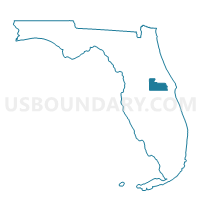
545-Voting District, Orange County, Florida
About
Outline

Summary
| Unique Area Identifier | 557015 |
| Name | 545-Voting District |
| County | Orange County |
| State | Florida |
| Area (square miles) | 97.71 |
| Land Area (square miles) | 95.73 |
| Water Area (square miles) | 1.98 |
| % of Land Area | 97.97 |
| % of Water Area | 2.03 |
| Latitude of the Internal Point | 28.53430740 |
| Longtitude of the Internal Point | -80.98973620 |
Maps


Graphs
Select a template below for downloading or customizing gragh for 545-Voting District, Orange County, Florida


Neighbors
Neighoring Voting District (by Name) Neighboring Voting District on the Map
- 119.01-Voting District 119, Area 1, County, Brevard County, FL
- 14.01-Voting District 14, Area 1, County, Brevard County, FL
- 425-Voting District, Volusia County, FL
- 445-Voting District, Orange County, FL
- 538-Voting District, Orange County, FL
- 539.1-Voting District, Orange County, FL
- 547-Voting District, Orange County, FL
- 7-Voting District, Seminole County, FL
- 74.01-Voting District 74, Area 1, County, Brevard County, FL
- 7E-Voting District, Seminole County, FL
Top 10 Neighboring County Subdivision (by Population) Neighboring County Subdivision on the Map
- Cocoa-Rockledge CCD, Brevard County, FL (117,219)
- Oviedo CCD, Seminole County, FL (93,610)
- Titusville CCD, Brevard County, FL (66,206)
- Central Volusia CCD, Volusia County, FL (36,156)
- East Orange CCD, Orange County, FL (34,186)
Top 10 Neighboring Place (by Population) Neighboring Place on the Map
Top 10 Neighboring Unified School District (by Population) Neighboring Unified School District on the Map
- Orange County School District, FL (1,145,956)
- Brevard County School District, FL (543,376)
- Volusia County School District, FL (494,593)
- Seminole County School District, FL (422,718)
Top 10 Neighboring State Legislative District Lower Chamber (by Population) Neighboring State Legislative District Lower Chamber on the Map
- State House District 33, FL (196,662)
- State House District 32, FL (177,523)
- State House District 28, FL (154,175)
Top 10 Neighboring State Legislative District Upper Chamber (by Population) Neighboring State Legislative District Upper Chamber on the Map
Top 10 Neighboring 111th Congressional District (by Population) Neighboring 111th Congressional District on the Map
Top 10 Neighboring Census Tract (by Population) Neighboring Census Tract on the Map
- Census Tract 167.04, Orange County, FL (14,527)
- Census Tract 712, Brevard County, FL (12,889)
- Census Tract 166.01, Orange County, FL (10,418)
- Census Tract 212.04, Seminole County, FL (9,769)
- Census Tract 166.02, Orange County, FL (9,241)
- Census Tract 832.09, Volusia County, FL (4,910)
- Census Tract 711, Brevard County, FL (3,880)
Top 10 Neighboring 5-Digit ZIP Code Tabulation Area (by Population) Neighboring 5-Digit ZIP Code Tabulation Area on the Map
- 32780, FL (34,628)
- 32926, FL (22,752)
- 32766, FL (15,698)
- 32754, FL (11,313)
- 32833, FL (9,241)
- 32820, FL (7,974)
- 32709, FL (2,566)